Shadowmark Maps › LiDAR sites › Fyfield Down
Fyfield Down in LiDAR
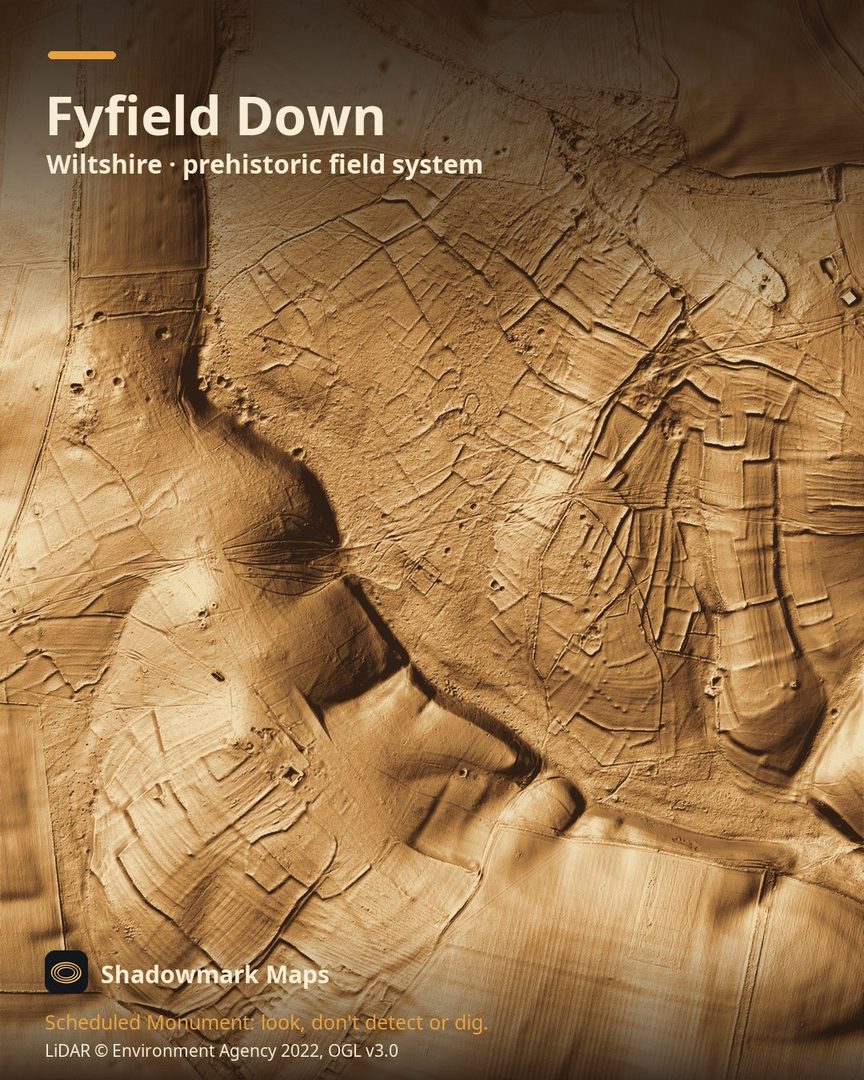
Fyfield Down is a prehistoric field system in Wiltshire. Here it is in the Environment Agency's 1 m LiDAR, shaded so the shape of the ground stands out. Look for a grid of rectilinear fields outlined by lynchet banks up to 3m high, crossed by the ruts and sunken tracks of Green Street, and barrows including a disc barrow beside the Ridgeway.
What you can see
- Long-term ploughing piled soil against the field edges, forming banks called lynchets that still stand up to 3m high in places. (Historic England)
- The main field systems, on the north and west of the monument, cover about 150ha; excavation suggests they date mainly from the Mid to Late Bronze Age, farmed on and off into the Iron Age. (Historic England)
- Green Street, a medieval road from London to Bath, crosses the downs as ruts and sunken tracks, and was abandoned around 1815. (Historic England)
- At least six barrows are clearly visible, the most westerly a disc barrow beside the Ridgeway on Overton Down. (Historic England)
Visiting
North Wessex Downs National Landscape says numerous footpaths and bridleways cross Fyfield Down and the Ridgeway National Trail runs along its boundary. (northwessexdowns.org.uk)
Official record: Historic England list entry 1019190: Prehistoric to post-medieval settlement, cultivation, industrial and funerary remains on Fyfield, Overton and Manton Downs.
Look, don't detect or dig
Fyfield Down is a Scheduled Monument, protected by law because it's of national importance. In England it's a criminal offence to use a metal detector on a Scheduled Monument without Historic England's written consent, and to remove any object of archaeological or historical interest found with one. Damaging a scheduled monument is an offence too, and works on one, including digging, need Scheduled Monument Consent first. More on Scheduled Monuments and the rules.
Keep to paths and open access land, and follow the Countryside Code.
Get an email when it launches
Shadowmark Maps is coming to the App Store and Google Play. Leave your email and we'll tell you when it's out, with the links to download it.
More sites in LiDAR
Avebury · West Kennet Long Barrow · Barbury Castle · Wayland's Smithy · all sites