Shadowmark Maps › LiDAR guide
How to read LiDAR maps
LiDAR terrain maps show the shape of the ground with the trees and buildings taken away. Banks, ditches and mounds that are hard to see when you're standing on them stand out clearly, which is how LiDAR has revealed so many new sites, from hillforts and barrows to Roman roads and lost fields. This guide shows what the common features look like, how to check what you've found, and the rules to follow before you go looking.
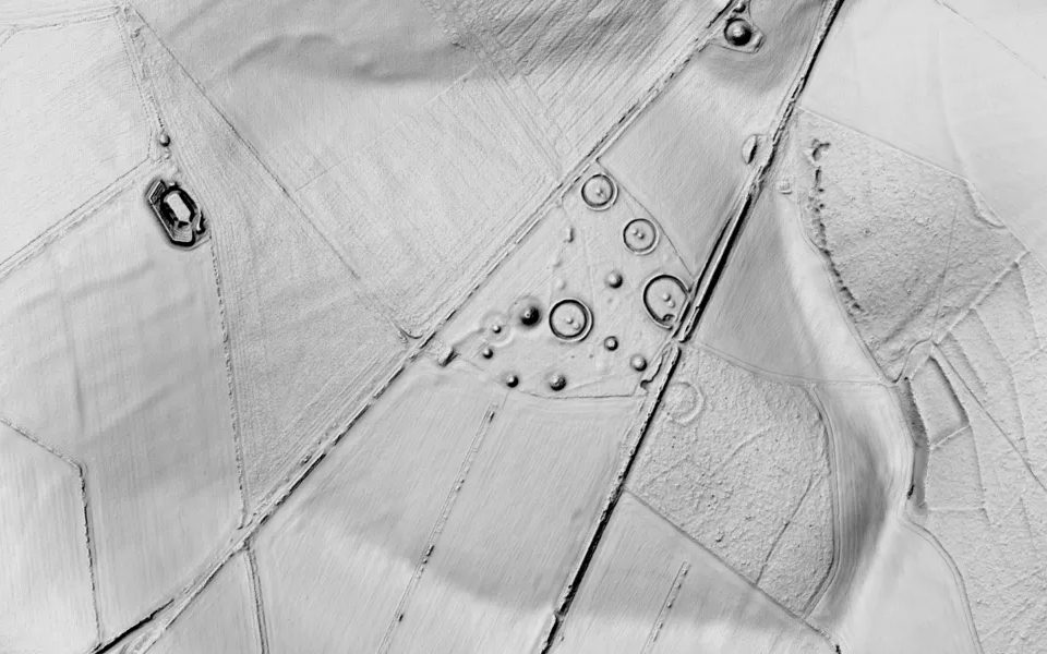
What a LiDAR map shows
LiDAR (light detection and ranging) measures the ground from an aircraft with millions of laser pulses. Some pulses reach the ground through gaps between leaves and branches, so the survey can be turned into a terrain model: the height of the bare earth, with trees and buildings removed. In England, the Environment Agency's terrain model covers about 99% of the country on a 1 metre grid.
A terrain model on its own is just heights. To make it readable, mapping software lights it from one direction, as if the sun were low in the sky, usually from the north-west. Slopes facing the light are bright and slopes facing away are dark, so even a low bank shows a bright side and a dark side. This is called hillshade, and it's what most free LiDAR viewers show.
How to read it
- Change the light. A bank that runs in the same direction as the light casts no shadow and can vanish. Views such as sky-view and local relief don't depend on the light's direction, so they show features of every orientation.
- Check the scale. A round barrow can be anything from about 5 m to over 50 m across; a hillfort's ramparts can enclose several hectares. Zoom out to see a whole field system, and in to see a single house platform.
- Expect modern lookalikes. Field drains, old quarries and pits, ponds, bomb craters, golf courses, tracks and recent landscaping can all look ancient. Compare with old Ordnance Survey maps, which show what was there a century or more ago.
- Look for patterns. Straight lines running for miles, rings in groups, rows of rectangular plots and parallel corrugations are rarely natural.
What the common features look like
Hillforts
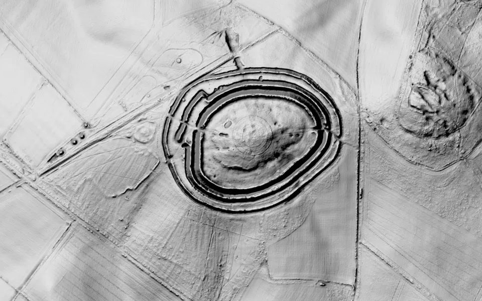
Iron Age hillforts are enclosures defended by one or more banks with ditches outside them (ramparts), usually following the contour of a hilltop or spur. On a LiDAR map they appear as rings or loops of paired light and dark lines, often with gaps for entrances. Many hillforts are now wooded, which is where LiDAR helps most.
Barrows (burial mounds)
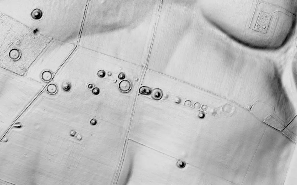
Round barrows are burial mounds, mostly of the Early Bronze Age (about 2000–1500 BC), some earlier. They're often surrounded by a ditch and often in groups along a ridge. Even ploughed-down barrows can show as faint rings. Long barrows, older and rarer, are long mounds with a ditch along each side.
Roman roads
Roman roads were built on a raised bank called an agger, often with a ditch on each side, and they run in long straight lines, changing direction on high ground. On LiDAR, look for a straight ridge or a pair of parallel ditches crossing fields and woods, often lined up with a modern road, a parish boundary or a hedge that keeps the same course. At Oakley Down (top of this page), Ackling Dyke's agger still stands well above the ground.
Ridge and furrow
Medieval and later ploughing in long strips left fields of parallel ridges, like corduroy, often in a gentle reverse-S curve where the ox teams turned. On LiDAR, ridge and furrow shows as fine parallel stripes, usually in blocks at different angles. It's common across the Midlands, and it's a sign of medieval or later ploughing rather than a find spot.
Deserted medieval villages
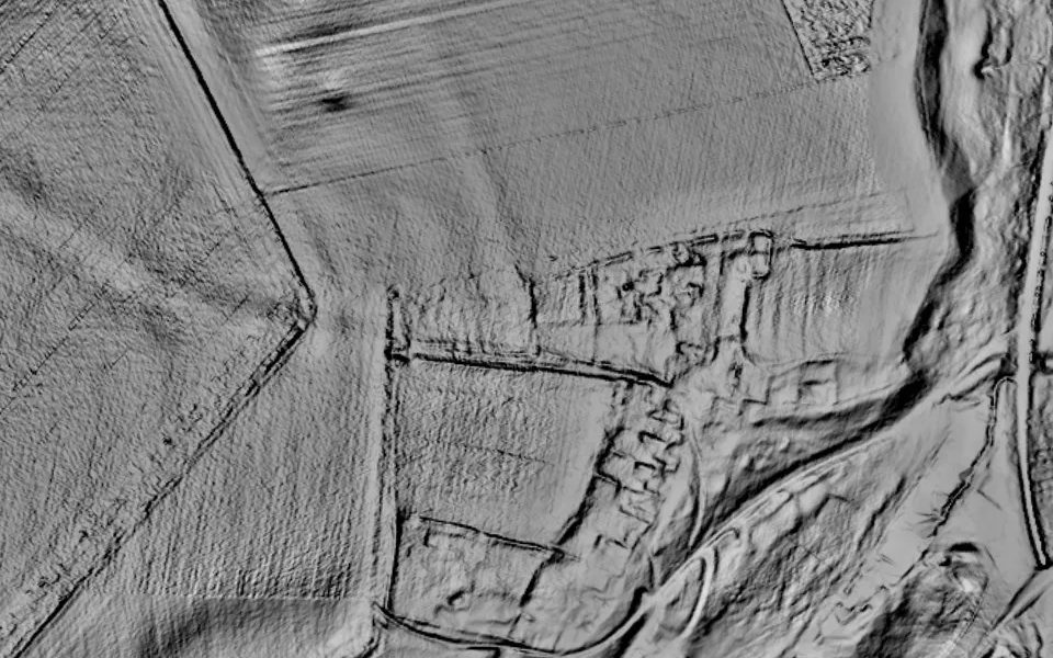
Thousands of English villages shrank or were abandoned in the Middle Ages. What's left are low banks around house plots (tofts and crofts), sunken lanes worn into the ground (hollow ways), and often ridge and furrow around them. Wharram Percy is one of the best known; English Heritage looks after it.
Ancient field systems
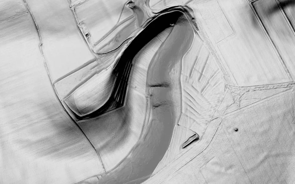
On chalk downland especially, prehistoric and Roman-era farmers left small, roughly rectangular fields. Soil crept downhill against their boundaries and built up banks called lynchets, which show on LiDAR as a grid or a series of steps on a slope.
All the places shown here are Scheduled Monuments: look, but don't detect or dig. The images are Shadowmark's own views of the Environment Agency's LIDAR Composite DTM 1 m, © Environment Agency copyright and/or database right 2022, used under the Open Government Licence v3.0. Historic England's list entries: Oakley Down barrows, Ackling Dyke, Badbury Rings, Normanton Down, Wharram Percy and Milton Hill.
Check what you've found
- Is it already known? Search Historic England's National Heritage List for England on its map, which shows Scheduled Monuments and listed sites. Local Historic Environment Records hold far more, many of them searchable through the Heritage Gateway.
- Compare with old maps. The National Library of Scotland's georeferenced maps let you compare old Ordnance Survey maps of England, Wales and Scotland with today's.
- Think you've found something new? Tell the Historic Environment Record for that county. Volunteers studying LiDAR have added many new sites to the record this way.
The rules before you go looking
- Permission. All land belongs to someone, including footpaths and beaches. You need the landowner's permission to search or detect anywhere, and a public footpath only gives you the right to walk along it.
- Scheduled Monuments. In England it's a criminal offence to use a metal detector on a Scheduled Monument without Historic England's written consent, or to remove an object of archaeological or historical interest found that way. The same applies in the Areas of Archaeological Importance in the historic centres of Canterbury, Chester, Exeter, Hereford and York. Damaging a scheduled monument is also an offence. The outlines in Shadowmark Maps are a guide; the official list is the authority.
- Treasure. In England, Wales and Northern Ireland, you must report finds that may be Treasure to the coroner within 14 days. For example: any object other than a coin that is at least 300 years old and at least 10% gold or silver, or two or more such coins found together.
- Recording. The Portable Antiquities Scheme records archaeological finds made by the public in England and Wales, through local Finds Liaison Officers.
- Good practice. Follow the Code of Practice for Responsible Metal Detecting in England and Wales.
- Scotland and Northern Ireland have different laws. In Scotland, all archaeological finds must be reported to the Treasure Trove Unit. In Northern Ireland you need a licence from the Department for Communities, usually given only for genuine archaeological research or rescue digs, to dig for archaeological objects anywhere. Carrying a detector on a scheduled or State Care monument is an offence, and every archaeological find must be reported within 14 days.
Questions people ask
Is LiDAR data free in the UK?
Yes. The Environment Agency publishes England's LiDAR free under the Open Government Licence, and Wales and Scotland publish theirs too (Scotland's covers only part of the country). You can download it for GIS software or view it in free web viewers. Shadowmark Maps shows England's on your phone, with offline areas and monument warnings.
Can I see LiDAR maps of my area?
Almost certainly, if you live in England: the 1 m terrain model covers about 99% of it. The coverage page lists the other countries in Shadowmark Maps.
Does LiDAR see through trees?
Often. Surveys flown in winter usually map the ground under broadleaf woodland, which is how LiDAR has found so many earthworks in forests. Young conifer plantations and thick undergrowth (bramble, bracken, holly) block most pulses, so features there can be missed.
Can you see Roman roads on LiDAR?
Often. Where a road's raised bank (the agger) survives, even ploughed low, LiDAR shows it as a straight raised band, sometimes with a ditch on each side. Follow the line across fields and woods, and check it against known routes and old maps.
Can LiDAR see underground?
No. Airborne LiDAR measures the surface. Buried remains show only where they change the shape of the ground, such as a ditch that has silted up into a slight hollow, or a wall that has left a low bank.
Can LiDAR detect metal?
No. It measures the height of the ground, so it can't detect metal or tell you what's buried. It shows where people built, farmed and travelled.
Can I metal detect on something I've found on LiDAR?
Only with the landowner's permission, and never on a Scheduled Monument without Historic England's consent. If it looks like an unrecorded site, report it to the county's Historic Environment Record instead.
LiDAR on your phone
Shadowmark Maps puts national LiDAR shading for England, France, the United States and more on one map, marks England's Scheduled Monuments in red, and warns you when you're on or near one. Pro adds the Shade, Detail, Relief, Sky-view and Combined views used on this page, 3D terrain and unlimited offline areas. It's coming soon to the App Store and Google Play.
Get an email when it launches
Shadowmark Maps is coming to the App Store and Google Play. Leave your email and we'll tell you when it's out, with the links to download it.